Cool with rainfall well above average - warm in the final week
To people struggling with colds, switching the central heating back on, cold days, dull and overcast skies - quite simply, June was a miserable month, but rescued slightly by a warm and sunnier final week.
Low pressure was either over or near to the UK from the very beginning of the month through to the 20th during which time only two days managed to reach the height of an average June day-time temperature (17.9°c) - otherwise it was all below average and included the lowest June day-time maximum recorded at this site when quite staggeringly and for the first time at this site, the maximum temperature couldn't even reach 10°c!
High pressure did at least build from the 22nd and suddenly we started to enjoy some dry, warmer and sunnier weather. The 27-28th being especially glorious with clear skies, albeit the 29th would be warmer still, but humid and much cloudier.
Rainfall was frequent up to 20th, heavy at times, but here in Cumbria we actually faired quite well when compared to other parts of the UK! By mid month we had already recorded average rainfall for the month, but after the 20th only the 23rd saw any meaningful rain and this fell overnight.
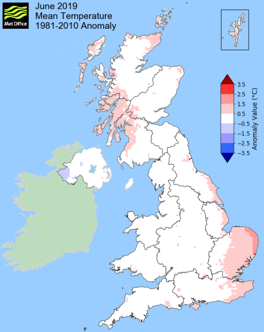
MSLP of 1013.9 Mb was -1.5 Mb below the local average for the month and overall a mean minimum of 8.56°c and a mean maximum of 17.11°c saw the temperature 0.47°c below the ten year average for this site.
It was the coldest since 2015 and of the eleven now recorded, three have been colder, six have been warmer and with one having the same mean temperature. The highest maximum temperature recorded was 27.5°c (29th), the lowest minimum 1.5°c (10th).
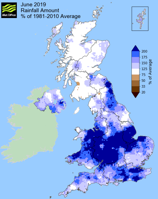
Rainfall of 113.8 mm (Crosby Ravensworth School 114.6 mm) was 139.8% of average for 2007-18 and made it the wettest June since 2017 - of the 13 now recorded three have been wetter and nine have been drier.
During the month, the following was recorded: thunder was heard on one day (24th).
At the Met' Office site at Newton Rigg, rainfall of 107.8 mm (184%) was the wettest since 2017 and in a series back to 1900 June has been wetter in nine years and drier in 110.
A mean temperature of 12.99°c is exactly average for the month and in a record back to 1914 (4yrs of missing data) June has been warmer in 49 years and colder in 52.
Locally, rainfall percentages saw a marginal east/west split in the county which unusually saw the east have a greater percentage fall and which was more consistently above 100%. However, a small area in the north-eastern part of the county fell back below its average.
Figures from the Environment Agency’s rainfall sites were, (figure in brackets being the monthly average for 1961-90) ‘Data kindly provided by the Hydrometry and Telemetry team of the Environment Agency (Penrith)’:
Kirkby Thore ** mm (42.2 mm)
Haresceugh Castle (Kirkoswald) 88.3 mm (69.3 mm)
Brothers Water 158.97 mm (131 mm) and
Orton (Shallowford) 134.2 mm (86.6 mm [average for 1967-2018])
145.6 mm ++ at Seathwaite Farm (Borrowdale - 177 mm [average for 1981-2010]).
** not available due to faulty gauge.
++ provisional as appears slightly low.
General Synoptic Report for the Month
Low pressure (LP) was a permanent feature during June, being either over or near to the UK from the start through to the 20th when high pressure (HP) finally built and remained through to the 29th, albeit not always a dominant feature.
During this time the month actually started mild(ish) but with overcast skies and either showers or drizzle. Our first heavy rain (11.6 mm) came during the afternoon and evening of the 4th and then in a slack pressure gradient the 6th did see some sunny spells.
The 7th and overnight into the 8th though were very wet (30.2 mm) as a deep area of LP that had built in France moved NE and would not clear out into the North Sea until late on the 8th, which itself saw another 9.1 mm of rain. The 8th was a cold day with the temperature stuck just above 10°c for most of the time, but did 'peak' at 11.8°c.
Behind that LP the pressure slackened and the 9-10th did see finally get to see some sunshine and with a maximum of 18.3°c the 10th became the first day of the month to attain the average temperature for June - but then it went back downhill!
LP systems would once again dominate. Initially LP built over Normandy and slowly moved north and then pivoted west over the UK and by the 15th was sat out in the Atlantic off the west coast of Eire when another centre of LP developed and moved across the UK - periods of rain or showers were common and it felt distinctly cool.
Under overcast skies the maximum temperature on the 11th was back down to a chilly 12.3°c and there was also a spell of heavy rain in the early evening. As the frontal systems began to spiral over the UK heavy rain arrived overnight into the 13th (crediting 14.6 mm back to the 12th) with the rain continuing through to tea-time. With the LP moving north and HP far out in the Atlantic it created a N'ly flow and now the temperature dipped even further, down to a very cool maximum of just 9.8°c (49.6°f) - now the lowest June maximum in my records.
In my now 11yrs of temperature records the 13th and 15th are still the only days in June that have not reached the height of 20°c - it had warmed up slightly by the 15th to 15.3°c, but it was a showery day and still that record continues.
Come the 16th it was also becoming noticeably breezy and whilst the temperature had recovered slightly, it didn't feel like it had. Fortunately any rain tended to fall overnight during this period with the 17-18th, whilst breezy, having sunny spells.
Come the 21st the LP had now virtually removed itself from the UK and HP finally began to ridge north from Biscay. In the mean-time the 20th - 21st whilst sunny were not especially warm at 15-17°c and after a cool night 21st/22nd and some early cloud the day perked up.
The HP in Biscay had migrated north and was sat just of Denmark on the 22nd - but a LP system had now replaced the HP in Biscay and was lurking with intent. This saw much warmer and humid air being drawn up and come the early hours (0630-0700 Hrs) of the 24th we had a brief thunderstorm. Along with rain late on the 23rd this gave a total of 13.6 mm credited back to the 23rd.
The 24-25th whilst not especially warm felt humid under overcast skies, but now at the month's end we finally saw some decent amounts of sunshine.
HP was now over the UK, moving into the North Sea and with an easterly breeze the skies totally cleared. The afternoon of the 26th saw the first meaningful sunshine, but the 27-28th were perfect summer days - clear blue skies and just the right temperature, 23.8°c (74.8°f). Whilst these two days failed to see a single cloud, the 29th did and it was both hot and humid, the temperature rising to a month's high of 27.5°c (81.5°f) as the HP began to slip east and a cold front approached the UK from the west. The cold front introduced cooler air and more cloud and the 30th saw the temperature 10°c on the day before.
Rainfall totalled 113.8 mm for the month, with rain recorded on 18 days of which 14 were 'Wet days' (1.0mm +).
The Mean Temperature for the month was 12.84°c -- The Mean Max' was 17.11°c -- The Mean Min' 8.56°c.
We had 0 Air Frosts in the month (year 33) -- Grass frosts totalled 1 (year 77).
The 1 foot soil temp ranged from a low of 12.5°c on the 13-14th to a high of 17.4°c on the 30th -- with a monthly mean of 14.2°c
The 1 meter soil temp ranged from a low of 11.4°c on the 1st - 2nd to a high of 13.5°c on the 30th -- with a monthly mean of 12.1°c
This makes the Jan' to June period of 2019 0.25°c warmer than the average for 2009-18 and with 96.9% of average rainfall for 2007-18
JANUARY 2010
FEBRUARY 2010
MARCH 2010
APRIL 2010
MAY 2010
JUNE 2010
JULY 2010
AUGUST 2010
SEPTEMBER 2010
OCTOBER 2010
NOVEMBER 2010
DECEMBER 2010
JANUARY 2011
FEBRUARY 2011
MARCH 2011
APRIL 2011
MAY 2011
JUNE 2011
JULY 2011
AUGUST 2011
SEPTEMBER 2011
OCTOBER 2011
NOVEMBER 2011
DECEMBER 2011
JANUARY 2012
FEBRUARY 2012
MARCH 2012
APRIL 2012
MAY 2012
JUNE 2012
JULY 2012
AUGUST 2012
SEPTEMBER 2012
OCTOBER 2012
NOVEMBER 2012
DECEMBER 2012
SUMMER 2012
REVIEW OF 2012
JANUARY 2013
FEBRUARY 2013
MARCH 2013
APRIL 2013
MAY 2013
JUNE 2013
JULY 2013
AUGUST 2013
SEPTEMBER 2013
OCTOBER 2013
NOVEMBER 2013
DECEMBER 2013
REVIEW OF 2013
JANUARY 2014
FEBRUARY 2014
MARCH 2014
APRIL 2014
MAY 2014
JUNE 2014
JULY 2014
AUGUST 2014
SEPTEMBER 2014
OCTOBER 2014
NOVEMBER 2014
DECEMBER 2014
WINTER 2014
REVIEW OF 2014
JANUARY 2015
FEBRUARY 2015
MARCH 2015
APRIL 2015
MAY 2015
JUNE 2015
JULY 2015
AUGUST 2015
SEPTEMBER 2015
OCTOBER 2015
NOVEMBER 2015
DECEMBER 2015
REVIEW OF 2015
JANUARY 2016
FEBRUARY 2016
MARCH 2016
APRIL 2016
MAY 2016
JUNE 2016
JULY 2016
AUGUST 2016
SEPTEMBER 2016
OCTOBER 2016
NOVEMBER 2016
DECEMBER 2016
REVIEW OF 2016
JANUARY 2017
FEBRUARY 2017
MARCH 2017
APRIL 2017
MAY 2017
JUNE 2017
JULY 2017
AUGUST 2017
SEPTEMBER 2017
OCTOBER 2017
NOVEMBER 2017
DECEMBER 2017
REVIEW OF 2017
JANUARY 2018
FEBRUARY 2018
MARCH 2018
APRIL 2018
MAY 2018
JUNE 2018
JULY 2018
AUGUST 2018
SEPTEMBER 2018
OCTOBER 2018
NOVEMBER 2018
DECEMBER 2018
REVIEW OF 2018
JANUARY 2019
FEBRUARY 2019
MARCH 2019
APRIL 2019
MAY 2019
OTHER ARTICLES
The Oldest Inhabitant
An Inch Of Scotch Mist
But it's meant to be Summer (Summer 2017)
© Darren Rogers 2010-19
Want to comment on this site? email